MLK Weekend Snow
Explore Jovanah Mckinney January 12, 2023
Explore Jovanah Mckinney January 12, 2023
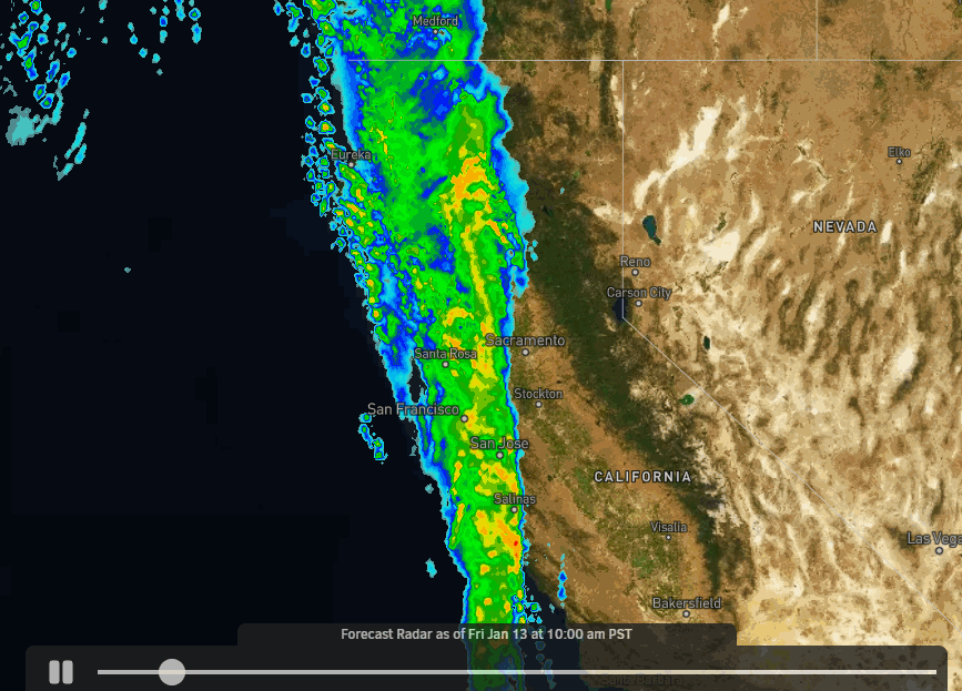
We are expecting a cold and snowy weekend with snow falling almost continuously from Friday afternoon through Monday night. Snow of varying intensity throughout the period. Ridgetop winds will be somewhat strong at times which could affect some lifts through the weekend. Heavy snow could cause morning lift delays or avalanche controls & digging out.
The next storm is forecast to move in by early afternoon Friday with snow showers continuing into Friday night. Snow levels could start up around 7000 ft. and then fall to the base by evening. Ridgetop winds gusting up to 70-80+ mph from the south-southwest, which could affect some upper mountain lifts. Highs in the 30s. We could see 2-4 inches of new snow at the base and 3-7 inches on the mountain by early Saturday morning.
A stronger storm moves in Saturday morning. We expect heavy snow from Saturday into Saturday evening. Then snow showers continue Saturday night. Highs drop into the 20s on the upper mountain and near freezing at the base. Ridgetop winds gusting up to 70-80+ mph from the southwest which could affect some upper mountain lifts again Saturday. By early Sunday morning, we could see an additional 12-17 inches of snow at the base and 13-23 inches on the mountain.
In total by Sunday morning we could see 2-day storm totals of:
Sunday could be a decent day for skiing. We are between storms with a moist flow and lighter snow showers or even scattered snow showers with some breaks possible. Ridgetop winds could drop to 40-50+ mph in the morning and possibly lower in the afternoon. Highs in the 20s on the mountain. Only Expecting around 1-3 inches of new snow during the day.
Sunday night moisture continues to flow into the Sierra with snow showers through the evening and then steadier snow moves back in by early Monday morning as the next storm moves in and continues through the afternoon. Then snow showers continue into Monday evening and taper off by Tuesday morning. Ridgetop winds from the southwest possibly increase to 50-60+ mph Monday which could affect a few lifts.
By early Tuesday morning, we could see 2-day storm totals of:
That would be 4-day weekend totals of around 2-4.5+ feet from bottom to top on the mountain!
We will see a break in the storms for Tuesday with partly sunny skies and cold temperatures. A few stray snow showers may be possible. It should be a nice powder day!
A final storm in the series is possible for Wednesday afternoon into Thursday morning. It looks to weaken quite a bit by the time it reaches the northern Sierra. We may only see a few inches of new snow at best. It stays cold with highs in the 20s up top and 30s at the base. We'll continue to watch the trends.
Then a drier pattern is still forecast to build in by the 20th through the last week of January. We may see a colder pattern with time with colder/weaker systems possibly dropping down from the north. So a drier pattern but not completely dry if the northerly flow pattern sets up.
We'll be watching the long-range forecast trends closely to see how long the drier period could last and when we will see more fresh snow.

Palisades Tahoe
Lake Tahoe Living

Palisades Tahoe

Real Estate

Palisades Tahoe
Lake Tahoe Living
An expert who brings unmatched insight and dedication to every transaction in the best markets.